|
|
| Regel 3: |
Regel 3: |
| |impressum=1627 | | |impressum=1627 |
| |cartograaf=Johannes Janssonius (1588-1664) | | |cartograaf=Johannes Janssonius (1588-1664) |
| |afbeelding=http://lh6.ggpht.com/_1AHWPR3ngw0/TSN5ppxMAPI/AAAAAAAAA2Q/st55vurhS5A/s500/1627-4.jpg | | |afbeelding=https://imsr2.hisgeolimburg.eu/i/ckRQt.jpg |
| |afbeelding_groot=http://lh6.ggpht.com/_1AHWPR3ngw0/TSN5ppxMAPI/AAAAAAAAA2Q/st55vurhS5A/s400/1627-4.jpg | | |afbeelding_groot=https://imsr2.hisgeolimburg.eu/i/ckRQ.jpg |
| |archiefstuk=http://lh6.ggpht.com/_1AHWPR3ngw0/TSN5rnjIIeI/AAAAAAAAA2U/I2Iv1FJeZB0/s1600/1627-4_01.jpg#http://lh6.ggpht.com/_1AHWPR3ngw0/TSN5tzRf-QI/AAAAAAAAA2Y/9IrHoiCmdcQ/s1600/1627-4_02.jpg#http://lh5.ggpht.com/_1AHWPR3ngw0/TSN5wbBY55I/AAAAAAAAA2c/sz28w7f5EW8/s1600/1627-4_03.jpg#http://lh3.ggpht.com/_1AHWPR3ngw0/TSN5yXba1EI/AAAAAAAAA2g/V7iL0oIh-3M/s1600/1627-4_04.jpg#http://lh5.ggpht.com/_1AHWPR3ngw0/TSN50r_vEaI/AAAAAAAAA2k/d72t2-NrGEc/s1600/1627-4_05.jpg#http://lh5.ggpht.com/_1AHWPR3ngw0/TSN53DpZ7VI/AAAAAAAAA2o/AqldqSUXiAo/s1600/1627-4_06.jpg#http://lh3.ggpht.com/_1AHWPR3ngw0/TSN55qiZiwI/AAAAAAAAA2s/97t7YUdcycA/s1600/1627-4_07.jpg#http://lh3.ggpht.com/_1AHWPR3ngw0/TSN57xFY9eI/AAAAAAAAA2w/jJEdPG0xuds/s1600/1627-4_08.jpg#http://lh4.ggpht.com/_1AHWPR3ngw0/TSN59sa6J5I/AAAAAAAAA20/CKDdkSjBOq4/s1600/1627-4_09.jpg#http://lh3.ggpht.com/_1AHWPR3ngw0/TSN5_2P8m7I/AAAAAAAAA28/e2WFnip4tf0/s1600/1627-4_10.jpg#http://lh5.ggpht.com/_1AHWPR3ngw0/TSN6CcrYgZI/AAAAAAAAA3A/anc-eADi1lw/s1600/1627-4_11.jpg#http://lh4.ggpht.com/_1AHWPR3ngw0/TSN6E3ux6_I/AAAAAAAAA3E/oyidMQCCbZs/s1600/1627-4_12.jpg|thumbnail=http://lh6.ggpht.com/_1AHWPR3ngw0/TSN5ppxMAPI/AAAAAAAAA2Q/st55vurhS5A/s518/1627-4.jpg | | |archiefstuk=RkjQ.jpg#ekjQ.jpg#vk5Q.jpg#8k5Q.jpg#Wk5Q.jpg#gkDQ.jpg#PkDQ.jpg#AkDQ.jpg#VkYQ.jpg#CkYQ.jpg#bkYQ.jpg#mkRQ.jpg |
| |archief=Historischer Verein für Geldern und Umgegend E.V. | | |archief=Historischer Verein für Geldern und Umgegend E.V. |
| |archief_url=http://www.archive.nrw.de/Kommunalarchive/KommunalarchiveE-H/G/Geldern_KleveKreis/index.html | | |archief_url=http://www.archive.nrw.de/Kommunalarchive/KommunalarchiveE-H/G/Geldern_KleveKreis/index.html |
Versie van 11 aug 2024 16:53
Terug naar Historische kaarten
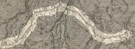
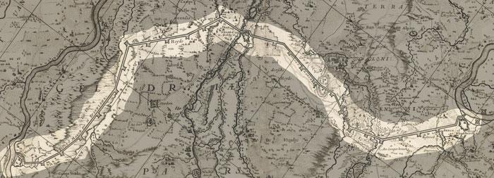
Impressum 1627

Cartograaf Johannes Janssonius (1588-1664)
Kaart afkomstig van Historischer Verein für Geldern und Umgegend E.V.
Links onder op de kaart staat Ducatus Sleswicensis, Nova Descriptio : Apud Janssonio-Waesbergios et Mosem Pitt volgens de website Worldcat is dit de cartograaf Johannes Janssonius (1588-1664)