1627:4: verschil tussen versies
k 1 versie geïmporteerd |
Geen bewerkingssamenvatting |
||
| (9 tussenliggende versies door dezelfde gebruiker niet weergegeven) | |||
| Regel 1: | Regel 1: | ||
{{sys:kaart:semantic | {{sys:kaart:semantic | ||
|kaart={{PAGENAME}} | |kaart={{PAGENAME}} | ||
|impressum=1627 | |impressum=1627 | ||
|afbeelding= | |cartograaf=Johannes Janssonius (1588-1664) | ||
|afbeelding_groot= | |afbeelding=https://mdsr.hisgeolimburg.eu/imsr/i/ckRQt.jpg | ||
|archiefstuk= | |afbeelding_groot=ckRQ.jpg | ||
|archiefstuk=RkjQ.jpg#ekjQ.jpg#vk5Q.jpg#8k5Q.jpg#Wk5Q.jpg#gkDQ.jpg#PkDQ.jpg#AkDQ.jpg#VkYQ.jpg#CkYQ.jpg#bkYQ.jpg#mkRQ.jpg | |||
|archief=Historischer Verein für Geldern und Umgegend E.V. | |archief=Historischer Verein für Geldern und Umgegend E.V. | ||
|archief_url=http://www.archive.nrw.de/Kommunalarchive/KommunalarchiveE-H/G/Geldern_KleveKreis/index.html | |archief_url=http://www.archive.nrw.de/Kommunalarchive/KommunalarchiveE-H/G/Geldern_KleveKreis/index.html | ||
|column=4 | |column=4 | ||
|zoom_width=492|zoom_height=442|zoom_left=-948|zoom_top=-698 | |zoom_width=492|zoom_height=442|zoom_left=-948|zoom_top=-698 | ||
}} | }}{{sys:terug|pagina=Historische kaarten}}{{sys:kaart:overzicht|kaart={{PAGENAME}}}}<br> | ||
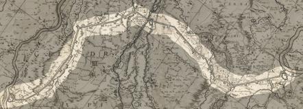
{{ | Links onder op de kaart staat ''Ducatus Sleswicensis, Nova Descriptio : Apud Janssonio-Waesbergios et Mosem Pitt'' volgens de website [https://www.worldcat.org/title/ducatus-sleswicensis-nova-descriptio-apud-janssonio-waesbergios-et-mosem-pitt/oclc/466267500 Worldcat] is dit de cartograaf [[Cartograaf:Johannes Janssonius (1588-1664)|Johannes Janssonius (1588-1664)]] | ||
[[Categorie:Cartograaf:Johannes Janssonius (1588-1664)]] | |||
[[Categorie:Archief:Historischer Verein für Geldern und Umgegend E.V.]] | |||
[[Categorie:17e eeuw]] | [[Categorie:17e eeuw]] | ||
Huidige versie van 1 dec 2025 om 17:28
Terug naar Historische kaarten
Impressum 1627
Cartograaf Johannes Janssonius (1588-1664)
Kaart afkomstig van Historischer Verein für Geldern und Umgegend E.V.
Links onder op de kaart staat Ducatus Sleswicensis, Nova Descriptio : Apud Janssonio-Waesbergios et Mosem Pitt volgens de website Worldcat is dit de cartograaf Johannes Janssonius (1588-1664)